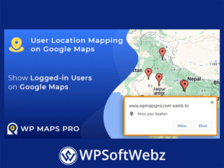

Enhance your WordPress site’s interactivity by displaying logged-in users’ real-time locations on Google Maps. The User Location Mapping on Google Maps add-on for WP Maps Pro enables dynamic visualization of user distribution, fostering community engagement and providing valuable insights.
📍 Real-Time User Location Display
Leverage browser-based geolocation to pinpoint and display users’ current positions:
- Automatic Location Detection: Upon granting permission, users’ locations are detected and marked on the map.
- Interactive Markers: Each user is represented by a customizable marker, enhancing map interactivity.
- Dynamic Listings: Accompanying listings provide additional user information, enriching the browsing experience.
🔧 Customizable and Scalable Integration
Tailor the add-on to fit your site’s specific needs:
- Role-Based Display: Choose which user roles are visible on the map, ensuring relevance and privacy.
- Custom Marker Icons: Assign unique icons to different user roles or categories for easy identification.
- Responsive Design: Ensure optimal display across all devices, from desktops to mobile phones.
🛠️ Seamless Integration with WP Maps Pro
Designed exclusively for WP Maps Pro, this add-on integrates effortlessly, enhancing the core plugin’s capabilities. Administrators can enable and configure the user location mapping feature through the intuitive backend interface, streamlining the setup process and ensuring a cohesive mapping experience.
📊 Ideal Use Cases
Implementing user location mapping is beneficial for various applications:
- Community Platforms: Visualize member distribution to foster connections and interactions.
- Event Management: Display attendees’ locations for meetups or conferences.
- Service Providers: Showcase available professionals or agents in specific regions.
- Educational Institutions: Map student or faculty locations for collaborative projects.
📝 Conclusion
The WP Maps Pro – User Location Mapping on Google Maps add-on is an invaluable tool for WordPress site owners seeking to visualize user distribution geographically. By bridging the gap between user data and interactive maps, it offers a dynamic and engaging way to present information, enhancing user experience and fostering community engagement.